by franz
DAY 1: ARRIVAL IN ANTANANARIVO
Arrival in Tana, meet and greet upon arrival in the capital of Madagascar. Then, transfer to your hotel GASSY COUNTRY HOUSE for the night, on B&B.
Antananarivo means “City of thousands”. Its story began 500 years ago, the king Andrianjaka sent over 1000 soldiers to cut the forest and to conquer the land. Then the great King Andrianampoinimerina, attracted by the beauty of the city, decided to build a palace there, which became later his successor’s main palace. From here the same king started to unify the different kingdoms of the island. During King Radama’s reign Antananarivo became the capital of all Madagascar. Antananarivo is build on 3 levels : the high city where the queen’s palace is situated, the first area occupied during the royal period, then the mid-city, the administrative area where all the better boutiques of the capital are found, then the low city which is the commercial area of the town.
DAY 2: TANA – ANTSIRABE: 169 km – 3 hours drive
After breakfast, city tours of Tana, the capital of Madagascar. Then by private car, 3 hours drive southward to Antsirabe across the highland landscape with its beautiful teraced rice-fields and its spectacular eroded hills called “lavaka”. Stop in Ambatolampy, an agricultural city, also known for its aluminum recycling workshops that we might visit during the weekdays. The next 2 hours, we’ll drive among rural scenery with thatched roof villages, valleys, rivers, rice and vegetables fields. This region supplies vegetables and rice to almost the whole country.
Arrival in Antsirabe, if time permits, we’ll have a short city tours, visit a lapidary of semi-precious gem, then a workshop making “pousse pousse” and cars in miniature. Night in the hotel LE ROYAL PALACE or similar, on B&B.
Antsirabe is an elegant city in the heart of Ankaratra massif. The name “Antsirabe” means «the place of much salt “, because of its natural hot spring and salty thermal source. Because of its mild and even cold temperature, Norwegians missionaries were attracted by the city and founded Antsirabe in 1856 and later used it as their base. Antsirabe is actually the only place which feels and looks like a European city because of its mild climate, its beautiful villas along the large tree-lined avenues.
Also known for its beerbrewing, Antsirabe is the main malt, barley and hops growing region in Madagascar. With its temperate climate and volcanic soil, all fruits and vegetable which grow in temperate/cold climates are found in Antsirabe. Surrounded by mines of semi-precious stones, Antsirabe is also known for gems and semi-precious stones factory and is a good place to buy gems and semi-precious stones.
DAY 3: ANTSIRABE – AMBOSITRA – ANTOETRA: 132 km – 2.5 hours drive
Today we drive southwards to Ivato center, 15 km from Ambositra, from there we take a beaten track of 20 km to Ambalandingana. Check –in and we start our hike to Antoetra. Overnight in hotel SOUS LE SOLEIL DE MADA or similar, on B&B.
Ambositra: 90 km south of Antsirabe, Ambositra is the centre of Madagascar’s wood carving industry, but belongs already to the province of Fianarantsoa. In the heart of the Highlands, this city reminds us the Far East with its terraced rice fields on, its hills and valleys, quietness and tranquillity, its green landscape, its pine and eucalyptus forests. One thing which marks the whole highland is its architecture. Almost all houses are made with ornately carved wooden balconies and shutters with nice colours. Ambositra and its surrounding are also known for the art of woodcarving and woodcraft. Many workshops can be visited in which we can see craftsmen at work.
DAY 4 : ANTOETRA: ZAFIMANIRY HIKE
Full day hike in Zafimaniry region where we will meet Zafimaniry people, discover its culture and way of living and also admire the beautiful landscape of this mountainous area.
Night in the same hotel on B&B.
Antoetra is known as the capital of Zafimaniry tribe and the starting point of different hikes to discover the Zafimaniry world. They are a sub tribe of the Betsileo,which is the third largest tribe in the country and the second tribe after Merina in the Highlands. Zafimaniry live mainly in the forest and live of forest exploitation. They are the masters of wood carving in the country and their wooden huts are made with carved windows frames and doors. Practically all wooden surfaces – walls, window frames, posts, beams, stools, chests, tools – display elaborate ornamentation. Their main characteristic is their high skill at woodcarving and wood crafting. They are the sole remaining people who still practice this unique woodcraft, a culture which was previously widespread over the whole island of Madagascar. Their art is classified as world heritage by UNESCO.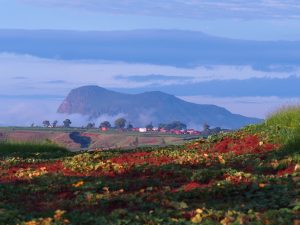
DAY 5 : ANTOETRA – AMBALAVAO – ANDRINGITRA: 217 km – 6 hours drive
We journey back to Ivato Center and take the National 7 down to Ambalavao. From there we take the beaten track to Andringitra where we stay and have 2 full days trekking. Check-in and overnight in the “Gite d’Andringitra” on full board.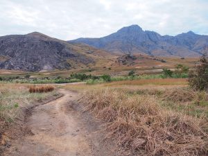
DAY 6 – 7 – 8: Hiking in Andringitra National Park
3 full days trekking with a special guide with camping on full board.
Andringitra National Park : Located 40 km east of Ambalavao, on a dirt track accessible only during dry season, created in 1999 with a surface of 31.160 ha, the National Park of Andringitra is situated in the Andrigitra Massif , a massif of granite and gneiss formations. Located at an altitude varying from 700 to 2658 meters, Andringitra has 3 types of vegetations. The lower altitude is dominated by eastern lowland rainforest where leguminous tree like “Dalbergia” are common. Then at higher altitude ( 800 – 1500 m), medium altitude rainforest where lichens and montane woodland are dominating. The highest altitude is dominated by high mountain prairies and alpine like vegetation. Being the 2nd highest peak of the country, with its Pic Boby ( 2400 m), the highest altitudes have recorded the lowest temperatures known in Madagascar ( -8°C) and snowfalls may occur in July and August. The attraction of Andringitra is especially the landscape, the tranquillity of the area and the walk inside the National park, through its granite mountain. Different treks from 4 hours to 4 days are offered to visitors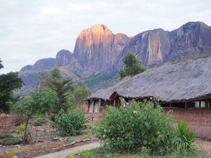
DAY 9: ANDRINGITRA – ISALO – ANDRIAMANERO :
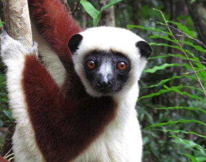
Early in the morning, we journey to Isalo and stop in Anja, a park run by the local community where part of the income serves to pay the teachers of the local school. We will spot ringtail lemurs during our visit of the park. Then we continue our drive down to Isalo, along the mountain chain of Andringitra, which serves as a transition between green highland and the dry south, then pass through Ihosy the capital of the Bara tribe, from there the landscape is changing and becomes more and more grandiose.
Huge Granite blocks are marking the spacious and empty plains. It is the “Gate of the South” which marks the end of the Highlands and the beginning of the South. We feel like being swallowed by this emptiness. We drive through “plateau de Horombe” a vast empty savannah, a red laterite soil. We are in “no-man’s land”. From time to time we can see herds of zebus, accompanied by armed Bara men who are darker – skinned with African features compared to Merina. They are cattle-raisers and many activities during their life are associated with Zebu. Estimated arrival around 11.00 in Isalo, and have 1 hour preparation for the 4 days trek inside the massif. By 12.00, we drive northward to Andriamanero, 37 km of dirt track from Ranohira village. From there we have 3km hike to reach the Natural swimming pool of Antsifotra, before settling to our camping place just 1,5km from there. Camping on full board.
DAY 10: hiking in Isalo National Park : Andriamanero – Ampandra: 13 km: denivelation 300 meter
Breakfast and hike to the Via Ferrata, a beautiful plateau offering a panoramic and breathtaking view of the whole massif. From there, 13km trek across canyons, massifs, oasis. Camping in Ampandra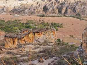
DAY 11: Isalo National Park trekking: Ampandra – Korobe: 11 km : 300 m
Today we hike from Ampandra till Korobe, 11 km of trek where we admire the scenery of the massif, its eroded sandstone composition giving different colours which match with the surrounding vegetation and soil. By the end of the afternoon, just enjoy the sunset on the plateaux of Korobe, with its different beautiful lights. Camping in Korobe on full board.
DAY 12: Isalo National Park trekking: Korobe – Betaimba: 13,5 km
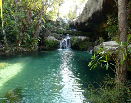
Our first step will be till the Natural swimming pool, about 10 km from Korobe. Enjoy the swim before walking up to Namaza, located 4km from there where we stop for our camping in Namaza.
Isalo National Park: Covering a massive area 81 504 ha, the Isalo Massif rises from the flat surrounding grassy plains. A spectacular landscape with its eroded sandstone massif, cut by deep canyons, making it the most breathtaking scenery and the most visited national park of the country. The scenery cunningly reminds us of the Fishriver Canyon in Namibia or the great Canyon in the USA, and offers many fantastic panoramic views of the eroded mountain with its different colours starting from yellow to red sometimes grey. The sandstone has been eroded into strange shapes, cut through by impressive gorges and canyons. Vegetation is concentrated in the canyon bottoms where streams flow. These wooded areas dominated by the fire-resistant Tapia-tree, on which a Malagasy endemic silkworm feeds. On the cliffs and rocks are several endemic succulents including the elephant’s foot and the localised endemic Isalo Aloe. What is special with this park is how nature seems to be in harmony. It’s amazing to find how plants have adapted to the harsh and dry climate of Isalo. We will see pachypodium, aloes, which grow in the rocks. These plants have a special roots and trunks where they store water when it rains. Then they can live without water for many months. This is also a place where the Bara tribe put their dead while saving money to buy silver coffins and the bodies in a safe place ! Isalo is not a place with high numbers of birds, Benson’s Rock- Trush, sub-species of the forest Rock-Trush , breeds in Relais de la Reine. Other birds that might be encountered include Lesser Vasa Parrot, White –Throated Rail, Madagascar Coucal, Madagascar Wagtail and Madagascar Kestrel.
DAY 13: Namaza – Isalo – Ifaty : 240 km – 3 to 4 hours drive
Today is our last hiking day, we hike through Namaza and by 10.00, we drive back to Ranohira that we reach by noon. From there we take the RN7 down to Tulear, the terminal of the National road N° 7. After 1 hours drive, stop in Ilakaka, a tiny village transformed into a busy town since the discovery of sapphire 15 years ago. From there, 1 hour drive to reach Zombitse National Park where you have 1 hour hike with a special guide in a semi-dry tropical forest, home to few endemic birds and 6 species of lemurs. From here, new scenery arises, composed with semi-dry forest of the west, baobabs tamarind trees, as we come closer to Tulear, we start to see thorny bush and from time to time some colourful tombs of Mahafaly and Antandroy tribes. Arrival in Tuléar, the end of this long and stunning National Road 7 that we reach in the afternoon. We take afterwards the National 9 and drive up northwards to Ifaty along the coast seeing mangroves, thorny bushes, dunes. On our arrival in Ifaty we check-in the hotel BELLE VUE or similar, on B&B.
DAY 14 : IFATY
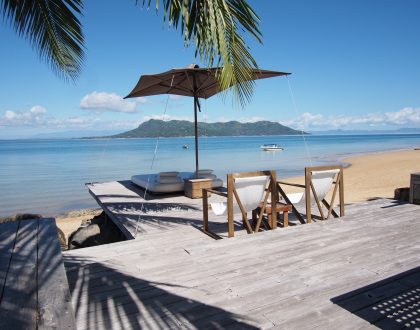
Located 24 km north of Tulear, a nice and lovely fisherman village bordering a wide lagoon. It is a popular beach resort for travellers searching a relaxing stay at the end of their trip. The climate is very dry and arid and from time to time local people suffer from the drought and lack of drinking water. Sand, dunes, spiny forest and thorny bushes as cactus, different euphorbiacea and didieracea are among the highlights of Ifaty. Mangroves are lining the coast alternating with Vezo fishermen villages. Many sail pirogues are lining the beach by the end of day, fishermen back from the ocean, bringing the catch of the day so that women and children can sell them in the restaurants and hotels nearby. Protected by a coral reef, Ifaty is one of the best places for diving and snorkelling. From June to September, humpback whales come along the warm water of the Mozambique Channel, making Ifaty one of the best spots for whale watching. Overnight at the same hotel BELLE VUE or similar, on B&B.
DAY 15: IFATY – TULEAR – TANA (Domestic Flight)
After breakfast, transfer to the airport and flight back to Tana. Once arrived, transfer to the hotel GASSY COUNTRY HOUSE, on B&B.
DAY 16: TANA – ANOTHER DESTINATION
Day off. Transfer to airport in time for your flight back home.
END OF SERVICE
Recommended Posts
Madagascar Northern Untamed : 14 nights – 15 days
July 17, 2018
32/ Family tour
May 28, 2018
25/ Madagascar, the Galapagos of Africa
May 28, 2018